
|
ARPS Model System Overview
In 1989, the Center for Analysis and Prediction of Storms was established
at the University of Oklahoma as one of the National Science Foundation's
first 11 Science and Technology (S&T) Centers. Its formal mission is to demonstrate
the practicability of storm-scale numerical weather prediction and to develop,
test, and validate a regional forecast system appropriate for operational,
commercial, and research applications. Its ultimate vision is to make available
a fully functioning stormscale NWP system around the turn of the century.
Central to achieving this goal is an entirely new three-dimensional, nonhydrostatic
model system known as the Advanced Regional Prediction System (ARPS). It is
a entirely new and complete numerical prediction system designed for the explicit
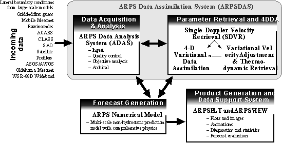
representation of convective and cold-season storms. It includes a data ingest,
quality control, and objective analysis package known as ADAS (ARPS Data Analysis
System), a single-Doppler radar parameter retrieval and assimilation system
known as ARPSDAS (ARPS Data Assimilation System, of which ADAS is a component),
the prediction model itself, which is the topic of this paper, and a post-processing
package known as ARPSPLT. These components are illustrated in the following
figure.
In planning for its development, the ARPS was required to meet a number
of criteria. First, it had to accommodate, through various assimilation strategies,
new data of higher temporal and spatial density (e.g., WSR-88D data) than
had traditionally been available. Second, the model had to serve as an effective
tool for studying the dynamics and predictability of storm-scale weather in
both idealized and more realistic settings. It must also handle atmospheric
phenomena ranging from regional scales down to micro-scales as interactions
across this spectrum are known to have profoundly important impacts on storm-scale
phenomena. These needs required that the model have a flexible and general
dynamic framework and include comprehensive physical processes. The system
should also run efficiently on massively parallel computers. In short, it
was our goal to develop a model system that can be used effectively for both
basic atmospheric research and operational numerical weather prediction, on
scales ranging from regional to micro-scales.
The numerical forecast component of the ARPS is a three-dimensional,
nonhydrostatic compressible model in generalized terrain-following coordinates
that has been designed to run on a variety of computing platforms ranging
from single-processor scalar workstations to massively parallel scalar and
scalar-vector processors. This highly modular code is extensively documented
and has been written using a consistent style throughout to promote ease of
learning and modifications well as maintainability. The present version contains
a comprehensive physics package and has been applied successfully during the
past few years to real-time operational prediction of storm-scale weather
over the Southern Great Plains of the United States.
Current Features and Capabilities of ARPS
After almost six years of development and testing, the
ARPS model now contains physics and numerical solution options consistent
with most other non-hydrostatic codes. It does, however, offer a number of
unique capabilities in documentation, code structure, scalability on parallel
platforms, and ease of use, and thus we summarize below the current features
of the system and highlight with underlining those which, in our judgement,
are unique to the ARPS. Specific accomplishments for 1997 are shown in
italics.
- Computer Language - Fortran-77 with Fortan-90
extensions.
- Documentation - Extensive in-code documentation
along with a comprehensive users guide.
- Code Design - Fully self-contained codes
that are completely portable among both conventional vector-scalar machines
(e.g., Cray J90, C90, T90, and workstations and PCs) as well as massively
parallel architectures (e.g., T3E, SP2, distributed homogeneous or heterogeneous
clusters). The model system is written with a single consistent coding style
using industry-standard practices to ensure readability, maintainability,
and ease of modification.
- Code Structure - The ARPS subroutines are organized
by functionality, and the entire software system is divided into sub-directories
based on code type and purpose.
- Availability - All source code and documentation
are available via the CAPS web site (http://www.caps.ou.edu) or an anonymous
ftp server (ftp.caps.ou.edu), including PDF and postscript versions
of the users guide.
- User Support - An e-mail based user support
system has been in place for several years and continues to be an effective
mechanism for dealing with user questions and for reporting bugs in the
code. An FAQ link has been added to the ARPS page, as well as a posting
of user questions and responses. Finally, a training and applications
support group has also been established for those users requiring
support beyond what is otherwise made available.
- Dynamic Framework - Nonhydrostatic and fully
compressible with Boussinesq option.
- Coordinate System - Generalized terrain-following
coordinate on the Arakawa C-grid with equal-spacing in the horizontal and
user-specified stretching in the vertical.
- Map Projections - Polar stereographic, Lambert
Conformal, and Mercator options.
- Domain Geometry - 1-D, 2-D, and 3-D configurations.
- Prognostic Variables - Cartesian wind components,
perturbation potential temperature and pressure, subgrid-scale turbulent
kinetic energy, mixing ratios for water vapor, cloud water, rainwater,
cloud ice, snow and graupel/hail.
- Spatial Discretization - Options for second-order
quadratically-conservative, fourth- order quadratically-conservative,
Zalesaks multi-dimensional flux corrected transport (FCT; positive definite),
and multidimensional positive definite centered difference (MPDCD) finite
difference schemes for advection. Second-order centered differences
are used for all other terms.
- Temporal Discretization - Second-order leapfrog
scheme for large time steps with Asselin time filter option. First-order
forward-backward explicit with second-order centered implicit option for
small (acoustic mode) time steps.
- Solution Technique - Split-explicit (mode-splitting)
with vertically-implicit option.
- Initial State - Options for horizontally-homogeneous
initialization using a single sounding or analytic functions, or a three-dimensional
horizontally inhomogeneous state.
- Lateral Boundary Conditions - Options for periodic,
rigid, zero-gradient, wave- radiating, externally-forced, and user-specified
conditions. All can be mixed and matched.
- Top & Bottom Boundary Conditions - Options
for rigid, zero-gradient, periodic, Durran-Klemp radiation, and Rayleigh
sponge layer.
- Divergence Damping - The model provides an option
for divergence damping to control acoustic oscillations.
- Reference Frame Rotation - Options for inclusion
of some or all Coriolis terms.
- Domain Translation - Options for user-specified
or automated (based on feature- tracking algorithms) translation of the
computational domain for horizontally homogeneous environments.
- Adaptive Mesh Refinement (AMR) - The Skamarock
AMR interface is available on shared memory machines for using unlimited
levels of grid nesting at arbitrary locations and orientations specified
at run time. One-way interactive self-nesting is also available.
- Subgrid Scale Turbulence - Options include Smagorinsky-Lilly
diagnostic first-order closure, 1.5-order turbulent kinetic energy formulation,
and Germano dynamic closure. The model also provides options for
isotropic and anisotropic turbulence based upon grid aspect ratio.
- Spatial Computational Mixing - 2nd- and 4th-order
options.
- PBL Scheme - Convective PBL turbulence based
on TKE scheme.
- Cloud Microphysics - Options for Kessler warm-rain,
Lin-Tao 3-category ice, and Schultz simplified ice NEM parameterizations.
The Lin-Tao scheme is now almost as computationally efficient as the Schultz
scheme due to the use of look-up tables and other optimization strategies.
- Cumulus Parameterization - Options for Kuo and
Kain-Fritsch schemes separately or in combination with other microphysics
options.
- Surface Layer Parameterization - Surface momentum,
heat, and moisture fluxes based on bulk aerodynamic drag laws as
well as stability-dependent formulations.
- Soil Model - Two-layer diffusive soil model
with surface energy budget equations. Options are provided for multiple
soil types in a single grid cell. An API initialization option
is also now available.
- Longwave and Shortwave Radiation - Full long-
and short-wave radiation capabilities including cloud interaction, cloud
shadowing, and terrain gradient effects.
- Surface Data - 1 km resolution (over US)
USDA surface characteristics database (soil type, seasonal vegetation
type) and pre-processing software.
- Terrain - 5 minute global terrain database,
30 second database for 70% of the earth, and 3 second data for the US.
A package is provided for processing these data.
- Real Data Ingest and Analysis - The ARPS
Data Analysis System (ADAS) provides the capability to ingest, quality
control, and objectively analyze (using the Bratseth or Barnes schemes)
virtually any type of observations including WSR-88D Level II data. CAPS
currently ingests: NIDS data from over 20 WSR-88D radars; surface and wind
profiler observations, rawinsonde observations, Level II data from the
Oklahoma City WSR-88D radar, conventional and Oklahoma Mesonet surface
observations, output from several NCEP models, and GOES satellite data.
- Links to External Models - Using GRIB and GEMPAK
readers, the EXT2ARPS package allows users to initialize and force the inner
domain and lateral boundaries of the ARPS with data from other models including
the RUC and Eta.
- ARPS Adjoint - The adjoint and tangent linear
versions of the warm-rain-option ARPS are available, with the adjoint
including the LBFGS minimization package.
- History Dumps - The ARPS supports the following
formats: unformatted binary, formatted ASCII, packed binary, NCSA HDF, NetCDF,
packed NetCDF, GrADS, GRIB, AVS, Savi3D, and Vis5D. These
formats can be read by post-processing programs provided with the model
or by user-created programs based on a template provided.
- Restart Option - Full restart capability is
available at intervals selected by the user.
- Compilation - The compilation of all programs
is handled by a single Unix shell script that invokes the Unix make command.
Computer system dependencies are automatically handled by the script
to facilitate easy migration among platforms and operating systems.
- Execution - Interactive (via a motif X-windows
interface) and batch execution are supported for ARPS and its post-processing
packages.
- Parallel Processor Options - The ARPS utilizes
the PVM and MPI message-passing libraries and a system-independent
translator for execution on distributed memory computers and clusters.
- User Interfaces - ARPS and its post-processing
packages utilize namelist input files which can be edited manually or configured
using a motif X-windows interface that is particularly helpful to
new users. In 1997, a web-based ARPS browser was implemented
using Pearl scripts.
- System Automation - The entire forecast
system, including data acquisition, quality control, analysis, retrieval,
assimilation, forecast model execution, and graphical product generation
and display (on the Web) is 100% automated by Unix shell scripts.
- Code Validation - A suite of code validation
tests is available, ranging from basic advection and symmetry tests
to analytic Navier-Stokes solutions and 3-D storm- and meso-scale simulations.
- Sample Datasets - CAPS provides a complete horizontally
inhomogeneous sample dataset for users interested in exploring the full
capabilities of the model.
- Graphical Post-Processing and Analysis - A vector
graphics post-processing package known as ARPSPlt is available for generating
color plots, 3-D wire frames, and profiles of basic and derived fields using
model-generated history data. The package supports overlays, color filling,
user-specified contour intervals and annotation, and multiple picture formats.
It is based on ZXPLOT, a vector graphics package similar to NCAR Graphics
that performs a variety of graphics functions and supports X-windows, GKS,
and postscript functionality. The ZXPLOT object code (only) is currently
available free of charge and is required for using ARPSPlt.
- Decision Support System - A web-based decision
support system known as ARPSView is available for the display of basic and
derived quantities from the model forecasts. This system is fully automated
with Unix shell scripts.
- Additional Analysis Tools - A combination of
software packages supplied by both local and external users is available
in ARPSTools. Capabilities include time-dependent trajectories, thermodynamic
diagrams and hodographs, and various statistics.
|
|